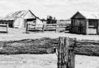
Finding your ancestors' homestead, or at least where it used to be, is a really exciting part of genealogy. If you know where they lived, you can go visit the place in person and see things from their perspective. While the area may have changed (though in some cases it may have not changed at all, or very little), you can get an idea of what your ancestors may have seen every day and the landscape, climate, and natural flora and fauna that shaped their daily lives. You can quite literally walk in their footsteps. It is a wonderful way to get closer to your ancestors and to know them better.
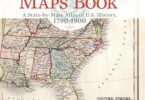
The best way to find where your ancestors lived, the actual precise location of their home and/or land, is to look at a plat map. Most county courthouses have old plat maps going back decades, and sometimes even centuries in some places. If you know the state and county where your ancestor lived, you can often locate their residence on plat maps, if the courthouse has maps going back far enough in time. You just need to look through the court's plat map books for the correct year or range of years that your ancestors lived in the county, then scrutinize the maps until you find their names.
Once you find their names on a plat map, you will need to know how to read the map to know where the residence was actually located. Plat maps show the land of the county divided into parcels and lots, and show who owned those parcels and lots at particular times. If you don't know how to read them, it can be quite confusing to know where to go to find your ancestors' homes.
To read the map, first look for the legend. Every plat map has one. It will tell you things, such as how many feet an inch equals on the map, as well as the orientation of the map (so you will know which way is north, south, east, and west).
Look for any numbers in the parcel or lot assigned to your ancestor. There will usually be one. The number tells you the dimensions of the parcel or lot in square feet, so you know how much land your ancestor owned.
If the map is a more recent one, or if your ancestors lived in a city, there will usually be street names on the plat map. Using the compass, the scale of inches to feet, and the placement of your ancestor's land on the map, you can typically find the homestead pretty easily.
In cases where your ancestor lived in the country, there likely will not be street names. You can still find the land by using the title of the map, which will tell you what area it is describing. You can still use the inch to feet key and compass to locate the land when you know what area it is in. Just figure out what is located at the edge of the map and use the legend to follow it to the parcel labeled as belonging to your ancestor.
Once you find the land, you can go there and see if a house still stands there, if a new house has replaced an old house, or if it is just empty land now. If you can access the empty land, you might even be able to find the foundations of the old house or some other remnants of it. Whatever you find there, you will have an excellent chance to take photos for your family genealogy that will be very valuable and useful to you and future generations.